|
|
|||||
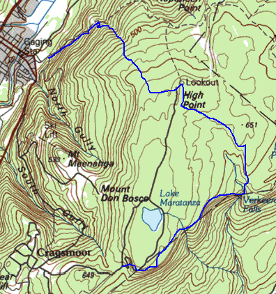
This page describes two hikes in Sam's Point Preserve. On the first, taken with several members of the 3500 Club, we started near Ellenville, explored one of the ice caves of Shingle Gully, and proceeded across the dwarf pine forest to High Point, Verkeerder Kill Falls, the commercial ice caves, and Sam's Point. Later I returned to spend more time exploring the ice caves and canyons of Shingle Gully.
 |
I had read, now and then, about the Ellenville Ice Caves. So when I saw in the
3500 club newsletter of a organized hike to the lesser known ice caves, I jumped at the
chance. It was a clear, hot day, so the prospect of exploring cool caves was doubly
attractive. There were six of us altogether: Ted, David, Danielle, John, Robert, and
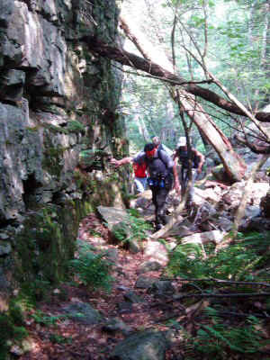
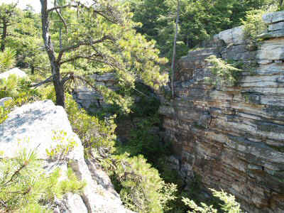
myself.. We hiked about a mile up the Smiley Carriageway, to a small wood bridge over a dry creek. We followed this creek (Shingle Gully) steeply upslope. There was a faint path, easy enough to follow. The gully become steeper and steeper. Suddenly, a vertical wall of rock appeared. It was odd, because I have seen plenty of cliffs, but they all ran across the slope, and this one ran up and down the slope. This was the beginning of the odd formation that forms the ice caves. The caves in this area are tectonic, not eroded or dissolved like most caves. In other words, they are formed by the natural movement of the ground. The geology of the area apparently consists of a layer of slippery shale underneath a hundred feet or more of much harder limestone/conglomerate. Where the whole formation leans, huge chunks of it break off and slide down a few feet at a time (called a block slide). This creates the deep cracks that make up the canyons. The ice caves of Shingle Gully are like a shark bite -- an inverted U, in the edge of the plateau. This shark bite is very obvious on the USGS topo maps of the area, but does not show up clearly on the lower resolution hiking maps, or on the maps available from the Sam's Point visitor center. You can see it in the rightmost map above. |
| Upper Shingle Gully (Wall Street) |
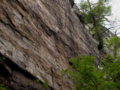
| This is the first deep portion of the canyon. Above the canyon it was scorching
hot and dry, down at the bottom it was cool and moist. Notice the ferns and mosses
-- notice also the constant fog. There was cold air pouring out of the cracks in the
side walls. We peered down several of the side caves, but they were a bit too steep for any of us to feel comfortable descending. I never really succeeded in keeping my glasses clear: I would wipe them off and in a few seconds they would fog up again. We inched along the bottom of the canyon, peering into side caves. The canyon floor was uneven -- piles of rock that had fallen in often blocked the way. |
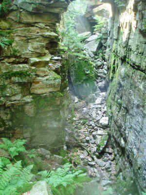 |
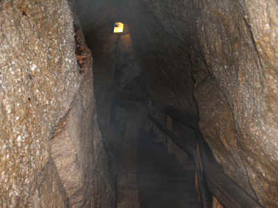
| Ice Cave |
 |
Eventually we got to a point where we could climb out, and we could see the
canyon from another perspective. The canyon extends for a considerable length, but there are some sections where it is made up of many parallel, very narrow sections that are too small to pass through. We intended to hike to another wide section, and explore it, but it proved difficult to find, and we had other sights we wanted to see. So we turned to the east, looking for the trail to High Point. |
| Canyon from above |
| The plateau is rocky and barren -- essentially solid limestone -- so the vegetation is
mostly bushes and stunted pines. It was refreshing to have a view while hiking
through the forest, but on this day of brutal sun,I would have traded it for shade. Before too long we reached High Point, where there were magnificent views in all directions. We could see most of the Gunks, as well as the southern peaks of the Catskills. |
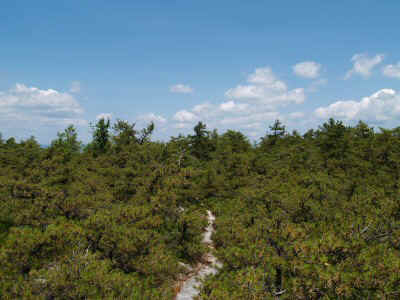 |
| Pygmy Pine Forest |
 |
We continued south and east on the rocky plateau to a small drainage surrounded by
cliffs. This drainage fed Verkeerder Kill Falls, which is on the horizon in this
picture. I would love to return and explore the lowlands at the base of the cliffs, but we did not have time for that this day. |
| Overlooking Plateau |
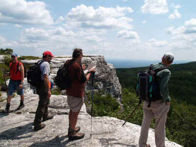
| The falls are at the eastern edge of the plateau: some of the water collected on top
pours over the side. I filled up my water bottle in the clear, cool stream, but I
did not get as close to the edge as these hikers.
|
 |
| Verkeerder Kill Falls |
 |
The trail continues along the edge of the plateau, to the site of an old tourist trap,
Ice Mountain Caves. These are the "commercial" ice caves. People
used to be able to drive to these, and walk through them for $6.50. The caves are
really a series of crevices in a cliff, and were not as deep, as narrow, or as cold as the
caves in Shingle Gully. They did build ladders, stairways, and walkways through
these formations. The caves were mildly interesting, but not worth $6.50. The trail continued around the edge of the plateau to Sam's Point, a viewpoint on the cliffs looking northwest. Some of our party, with better vision, could see as far as High Point New Jersey. It was a short descent from the viewpoint to the parking lot. |
| Commercial Ice Cave |
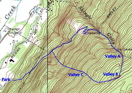
I was curious about the extent of the canyons and caves that we had only superficially explored, so I decided to go back and explore them more fully. I wanted to find the end of the canyon we had been in, and to find the other segments we had missed. I brought along a GPS to mark the locations of what I fund. I picked another hot day, thinking that the deep canyons would be an ideal place to escape from the heat.
I wanted to get an early start, so I left home at 5:00 AM in order to get to the Sam's Point permit office at opening time at 8:00. But the person who gives out the permits was not expected in until 9, so the person in charge told me to just go ahead without one. So I was on the trail by 8:15.
On the hike last month, the group had moved ever so slightly faster than I was comfortable hiking. My ankle was still tender from its sprain a month before, so I was carefully stepping over and around rough spots, giving me little time to enjoy the surroundings. This time I could move at my own pace, stop and take pictures, hike fast or slow, and notice the things I had missed the time before.
The first thing I noticed on the carriageway was a distinct use trail, about 1/4 mile from the parking area, heading up slope. At this elevation it was not obviously following a stream or other natural feature -- just heading up the mountain side. I wondered about this, and stored its location as a waypoint and moved on. Soon I was leaving the trail and heading up Shingle Gully. I remembered most of the details of its ascent pretty well, and was making good time. However, at a critical point, I left the bottom of the stream bed and climbed up where it was not so steep. I was intending to return, but eventually I found that I was on the plateau, and had missed the canyon entirely. I turned left, toward the stream bed I had left, and came upon the canyon spread out below me. I
I followed the canyon rim back down, keeping it in sight at all times. Soon I was right back where I had left the canyon. This time I stayed right in the streambed, and saw the wall rise up beside me. In a short while I was back at the ice caves we had visited before.
 |
I tried harder to climb down into the largest of the caves, but again the combination
of fogged glasses and steep drop-offs made me stop. It looks like the cave is about
20 feet deep, but there is no convenient ledge between the mouth of the cave and its
floor. I wanted to see what was beyond the bend (maybe nothing, maybe more cave)
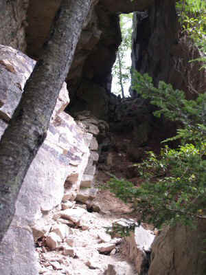
and what was giving rise to so much cold air. Maybe next time I will make it down. I spotted the exit we had used the last time. When I climbed up, I was at the exact spot I had been earlier in the day. If I had not just climbed up, I would never be able to find it. From above, it was just an inconspicuous crack hidden behind bushes. |
| First Exit |
| I continued on past the place we exited before, continuing to explore the canyon. It continued quite a way farther, eventually narrowing and petering out altogether. | 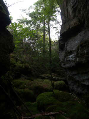 |
| Upper Section of First Canyon |
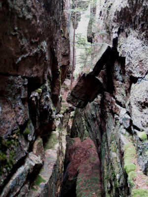 |
I explored a number of side canyons in this upper section of the canyon. At the end of the section, the floor formed a steep ramp that led up to the plateau alongside the network of faint trails I recognized from the previous trip. I got out a compass to help me head in the direction of the next set of canyons, as shown on the map. The terrain was pretty flat, so the other clues were pretty sparse. |
| Side Cracks of First Canyon |
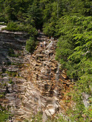
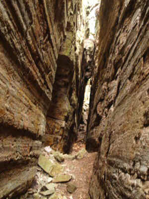
| I passed several narrow but deep cracks before coming to the edge of another wide canyon, with vertical walls of 40 to 50 feet. This section is sometimes called the "grand canyon." I followed the edge of the canyon until I found a way to enter, at the northern end. | 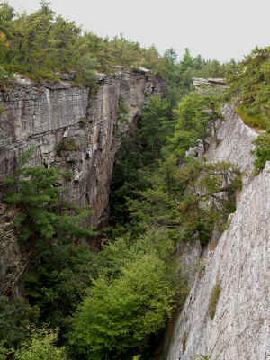 |
| Second (Grand) Canyon |
 |
Once I was on the floor of the canyon, I could travel its length pretty easily. This canyon was wider, deeper, and longer than the first. |
| Inside Grand Canyon |
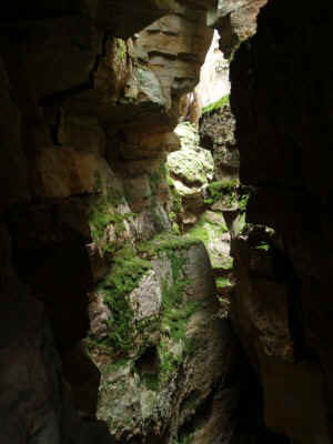
| Although it had many side canyons, there were none that emitted as much cold, moist air as the first one. | 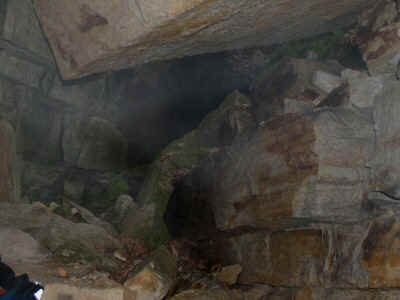 |
| Cave in Grand Canyon |
 |
This canyon consisted, in places, of systems of parallel interconnected canyons. This section is called, by some, the "Labyringh." I explored a few of the crack systems as I traveled along its length. When I finally reached the end, there were only sheer walls -- no way out. So I backed up and crawled along a narrow ledge to an adjoining canyon, which continued some ways farther. Finally, I discovered a section that I could climb: there were a few footholds and two excellent handholds that were tree roots. Once I emerged onto the plateau, I again was again unable to easily spot the way I had emerged. |
| Side Caves Grand canyon |
| Continuing on, I followed narrow crack systems that I could jump or step over, until I came upon a third large opening. This one was near a marked trail, and had numerous names (some from the early part of the century) painted on the walls. All the graffiti was kind of revolting, as was the trash and debris at the bottom. Although it was dark and damp at the bottom, the canyon was pretty short and unimpressive. I returned the way I had entered. | 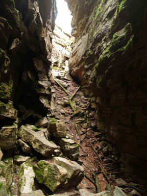 |
| Third Cave Entrance |
 |
By this point, the trail was heading more and more down the slope. It seemed to
be following the canyons, so I followed the trail down. The canyon at this point was
pretty deep, but too narrow to walk through, so I just followed along on top. A
little while later, at a point when the canyon was again parallel to the slope, it opened
wide enough to enter. This section is called "flume Gorge." I
climbed down and followed the canyon, no more then six feet wide, for what seemed like a
quarter mile. All this time the canyon was descending steeply down the slope.
I just hoped that I would be able to get out at the bottom, and would not be trapped and
have to climb all the way back up. The canyon kept narrowing, and was finally
blocked by a boulder that had fallen in and gotten wedged inside. Thankfully there
was a way out near that point, and I got back up to the surface. I quickly found the
trail, which iwas the same one I had noticed in the way in. A few minutes later I
emerged on the carriageway. Although I did not find any ice in the ice caves, the day was very satisfying. I have always loved climbing around on rocks, and this was just challenging enough to satisfy me. |
| Fourth Canyon (Flume Gorge) |
I have GPS coordinates for the various entry and exit points, which I will email you upon request.